Get Chitika Premium

Thursday, November 24, 2011

Introduction


Nepal(the Federal Democratic Republic of Nepal) is a landlocked sovereign state  With an area of
147,181 square kilometers located in South Asia in the Himalayas and bordered to the north by the China, and to the south, east, and west by the  India.Nepal is the world's 93rd largest country by land mass(has population of approximately 30 million) and the 41st most populous country. Kathmandu is the nation's.
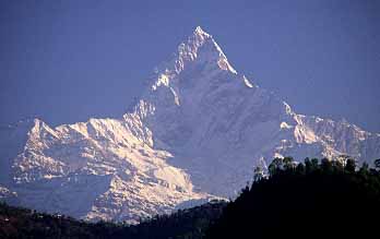
Nepal has a rich geography and has eight of the worlds ten tallest mountains of the world, including the highest point on Earth, Mount Everest, called Sagarmatha in Nepali. Nepal has more than 240 peaks over 20,000 ft(6,096 m) above sea level.
Hinduism is practised by a majority of people in Nepal than in any other nation and Buddhism, though a minority faith in the country,and is linked historically with Nepal. Many people in Nepali do not
distinguish between Hinduism and Buddhism and follow both religious traditions.
Nepal was ruled by the Shah dynasty of kings from 1768, when Prithvi Narayan Shah unified its many
small kingdoms.

Mount Everest


Elevation (feet): 29035
Elevation (meters): 8850
Continent: Asia
Country: Nepal/China
Region: Himalaya
SubRange: Central Nepal Himalaya
Latitude: 27.9881
Longitude: 86.9253
Difficulty: Major Mountain Expedition
Best months for climbing: April, May
Year first climbed: 1953
First successful climber(s): Edmund Hillary, Tenzing Norgay
Convenient Center: Namche Bazar, Nepal
Nearest major airport: Kathmandu, Nepal

Mount Everest is the highest mountain in the world. Its elevation was determined using GPS satellite on May 5, 1999. It was previously believed to be slightly lower. The new elevation has been confirmed by the National Geographic Society.Unsuccessful attempts was continued 1921-1952.The first successful attempt was in 1953.In 1922 was the first time that some climbers succeeded to climg the Mount Everest with the help of bottled oxygen.
The flora and fauna is poor on this mount, because of its high altitude. Some species of birds have been seen here, as for example the Bar-headed Goose and Chough.
The National Geographic Society has determined the height to be 6 feet taller, 29,035 feet, but the Nepali government has not made this new altitude official.

Rara Lake


Mahendra Daha (the late king of Nepal) known as Rara lake and lies at an altitude above 3.2 km (2.0 mi) above sea level covering an area of 16 km2. It is the biggest lake of Nepal, situated near district headquarters of Mugu and Talcha air strip in Mugu district in the Far Western Development Region. In able to reach to Rara Lake we should walk around 3 to 4 days from Jumla. The length is 5 kilometers and 2 kilometers wide, at the altitude around 3060 m. The max. depth of Rara Lake is 167 meter. Rara lake is the unique spot which is a part of Rara National park. It is located in a remote place. The view of Rara lake is very pleasing and it is one of the great place that should be visited. The Rara National Park is the home of precious animal like:-Himalayan black bear, Red panda, Ghorals etc. It is also known as Natures paradise.It is one of  the  treasure of  Nepal .  So don't  forget to visit  Rara Lake  for  great site and adventure.

Lumbini


Lumbini (lovely in sanskrit) is the birth place of Siddhartha Gautama (Lord  Buddha). Lumbini is situated in Rupandehi district 25 km east from kapilvastu of Nepal. At around 500 BCE Siddhartha Gautama (Buddha, founder of buddhist) was borned by Queen mother Maya Devi. Lumbini was the place where Buddha lived till he was 29. King Suddhodhan was the father of Gautama Buddha and was of Shakya dynasty. So Lumbini has a historical value and it is also known as the holy place for buddhist. It is place that should be visited at least one time in the life. Buddha is also known as Tathagata (who knows the truth).Lumbini is amazing place. Lumbini has many temples like Maya Devi temple, Holy Pond where where Buddha was taken by his mother for ritual dip and had a first bath. Buddhist has always respected the law of nature.The Lumbini is described in the Pali and Sanskrit literature. Lumbini is very important place historically and religiously.There is a pillar made by the great supporter of Buddha/Buddhist made by the king of India named Ashoka and the pillar is named as Ashoka Pillar.


Sunkoshi


Sunkoshi is also known as Matsang Tsangpo or River of Gold originated form Tibet.Sunkoshi is considered as one of the ten best rafting/kayaking rivers in the world and has grade III-IV rapids. So, it is one of the fabulous place in Nepal. Rafting in Sun Koshi river is a wild experience which fills thrill to the rafter and the current of the river is very good. It is great for adventure but all the months are not safe for rafting/kayaking.
Location:-Eastern Nepal
Nickname:-River of Gold
Distance:-270 km
Accessibility:-3 hours drive, east to Kathmandu
Put-in point:-Dolalghat
Put-out point: - Chatara
Time for Rafting:- Jan.-May  III to IV+ 
                            Jun.-Aug. X
                            Sep.-Dec. III to V
The common put-in-point is Dolalghat at a height of 620 meters (2,030 ft) and Put-out point is Chatara gorge at 115 meters (377 ft).if you like adventure or rafting or kayaking then this it the place you should visit once  in your lifetime. While rafting Mahabharata range can be viewed while flowing rapidly in the river.Sun Kosi's volume increases as it combines with seven big tributaries to become one of the major river of South Asia.

Devi's Falls


Length : 500 meters underground water flow.
Depth : 100 Feets.
More attractive month : June, July, August and September.
How was the name Devi's Falls originated?
On 31st july 1961 A.D. in the afternoon a sudden flood from Fewa Lake swept away a Swiss citizen Mrs. Devis who was having a bath with her husband beside it. She was flowed and dead.
She was recovered after a long attempt since then. It has been taken its name "Devi's Fall"

Davis Fall Locally known as Patale Chhango or Hell’s Falls is the most famous water fall in Pokhara, which comes to its gushing best just before disappearing underground.Devi's fall is pronounced in different ways by different people like:-Davi's Fall,David’s Falls, Devin Falls etc.The water in the Devi's Falls comes from Phewa lake flowing through a rocky stream, eventually rush down a waterfall and disappear in the ground.the best time to visit Devi's fall is during Monsoon when there is a rain fall and water level rises and the view is more awesome.

Makalu


Elevation (feet): -27765
Elevation (meters):-8462
Continent: -Asia
Country: -Nepal/China
Range/Region:-                Himalaya
SubRange: -Central Nepal Himalaya
Latitude: -27.889915
Longitude:-87.089396
Difficulty:-Major Mountain Expedition
Best months for climbing:-April, May
Year first climbed:-1955
First successful climber(s):-J. Franco's French Expedition
Nearest major airport:-Kathmandu, Nepal


Makalu[8,481 metres (27,825 ft) ]  is the fifth highest mountain in the world and is located 19 km (12 mi) southeast of Mount Everest, on the border between Nepal and China. Makalu is an isolated peak whose shape is of a perfect pyramid with four sharp ridges, makes this mountain all the more spectacular. It was not attempted until the summit of Everest had been attained in 1954.It has proved to be very challenging climb only five of its first sixteen attempts were successful. Makalu is considered as one of the most difficult mountain in the world to climb. It notorious for its steep pitches and knife-edged ridges that are completely open to the elements. The final ascent of the summit pyramid involves technical rock/ice climbing.


Phewa Lake


Phewa Lake or Phewa Tal or Fewa Lake784 m (2,572 ft) is a fabulous lake located in the Pokhara Valley. It is the second largest lake in Nepal and covers an area of about 4.43 km2 with an average depth of about 8.6 m (28 ft) with maximum water depth is 22.8 m (75 ft) when measured with an echo-sounder on 5 December 2009. Maximum water capacity of the lake is approx. 46,000,000 cubic metres (37,000 acre ft).The lake is famous for the reflection of Mount Machapuchare on its surface.The holy temple (Varahai mandir) is located on an island in the lake. 
Phewa Lake is also used for commercial fishing.To the east of the valley There are few smaller and few bigger lakes like Begnas Tal and Rupa Tal etc.
Phewa Lake is slightly enlarged by damming. It is in danger  situation of silting up. The outflowing water is partially used for hydropower. The dam collapsed in the late 1970s and it was rebuilt by the Chinese. The power plant is located about 100 m (330 ft) below at the bottom of the Phusre Khola. Phewa tal is very famous among Nepalese and tourists as well. It attaracts a lot of people and is very important Naturally or religiously.

Machhapuchhre


Machapuchare or Machhapuchhre "Fish Tail" in English, is a mountain in the Annapurna Himalayas of north central Nepal is located at about 25 km north of Pokhara and is one of the virgin peak, the main town of the region. It is revered by the local population as particularly sacred to the god Shiva, and hence is off limits to climbing. Machapuchhre is a favorite trekking destination, and the site of the base camps for the South Face of Annapurna and for numerous smaller objectives. 
Its double summit resembles the tail of a fish, hence the name meaning "Fish's Tail" in Nepali language It is also nicknamed the "Matterhorn of Nepal".
Machapuchare has never been climbed to its summit. The only attempt was in 1957 by a British team led by Jimmy Roberts. Climbers Wilfrid Noyce and A. D. M. Cox climbed to within 50 m of the summit via the north ridge, but did not complete the ascent; they had promised not to set foot on the actual summit. Since then, the mountain has been declared sacred, and it is now forbidden to climbers
Overview:-
Location:-Pokhara, Western Himalayas
Height:-6,993 m
Climbing:-Not allowed
Range of Mountains:-Annapurna Range
Attraction:-Majestic View

Bhote Koshi


Bhote Koshi or Rongshar Tsangpo is part of the Kosi or Sapta Kosiriver system in Nepal originated from Tibet. Bhote Koshi is another fabulous place of  Nepal. It is a tourist destination and famous for rafting, bunjee jumping.
Bhote Kosi River remains a favourite for its fast-paced adventure and thrills of river rafting. Bhote Kosi offers numerous photographic moments and opportunities to visit unexplored archaeological sites and abandoned areas.Best time for rafting along this river is from October to December and From February to April.
Season             Grade
Jan.-May         III to IV+
Jun.-Aug.             -
Sep.-Dec.        III to V-
Bungee jumping overthe Bhote Kosi has been described as the ‘ultimate experience’The valley is narrow with steep hillsides towering over 2,000 metres (6,600 ft) from theriver. Nepal's first bungee jumping site is situated at Last Resort, 160 metres(520 ft) above a gorge with the river raging below. It is 12Km  from the Nepal-Tibet border. Bungee jumping at the Last Resort is one of the longest in the world. It is higher than the highest bungee in the New Zealand. When it opened in 1999, the Last Resort was amongst the highest suspension footbridges in the world. Swiss designed, especially for bungee jumping with a 4x safety factor, the bridge will hold 4.5 tonnes. Over 6,000 metres (20,000 ft) of steel wire was used to build the longest suspension bridge in Nepal. The bridge site also encompasses hiking, rafting and mountain biking as well as overnight stays in a tent.

Swayambhunath


The Buddhist temple of Swayambhunath, situated on the top of a hill, west of Kathmandu, is one of the most popular, holy and instantly recognizable symbols of Nepal. The temple is colloquially known as the 'monkey temple' because of the large tribe of roving monkeys who guard the temple.
Fast Facts
Location :-Kathmandu Valley
Era :-Before 5th century
Unique Feature:-365 steps lead to the Temple that is believed to be 'Self-Created' or 'Self-Existence'
Category :-Wold Heritage Site
A top Syambunath hill is another fascinating, though less visited temple, Shantipur, popularly known as the 'Palace of Peace'. It is said that inside the secret underground chamber of the temple lives the 8th century Tantric master, Shantikar Acharya. The master, it is believed, has lived through centuries and has full control on the weather and the King of Kathmandu must go to him in times of drought.
According to Swayambhu Puran, the entire Kathmandu valley was once filled with an enormous lake, out of which grew a mystical Lotus. The valley came to be known as Swayambhu, meaning 'Self-Created' or 'Self-Existent'. The Bodhistava Manjushri had a vision of the lotus at Swayambhu and traveled there to worship it.
Swayambhunath Stupa is a golden spire crowning a conical wooded hill. It is the most ancient and enigmatic of all the holy shrines in Kathmandu Valley. It has a lofty white dome and a glittering golden spire that are visible from all sides of the valley. Historical records found on a stone inscription give evidence that the stupa was already an important Buddhist pilgrimage destination by the 5th century A.D. i.e. before the coming of Buddhism in the valley.

World Peace Pagoda Temple


A Peace Pagoda is a Buddhist stupa designed to provide a focus for people of all races and creeds, and to help unite them in their search for world peace. Most have been built under the guidance of Nichidatsu Fujii (1885–1985), a Buddhist monk from Japan and founder of the Nipponzan-Myōhōji Buddhist Order. In 1947, he began constructing Peace Pagodas as shrines to World peace.The first Peace Pagodas were built as a symbol of peace in the Japanese cities of Hiroshima and Nagasaki where the atomic bombs took the lives of over 150,000 people, almost all of whom were civilian, at the end of World War II. By 2000, eighty Peace Pagodas had been built around the world in Europe, Asia, and the United States.
The Peace Pagoda was awarded the Courage of Conscience award June 5, 1998 in Sherborn, Massachusetts 
Balanced on a narrow ridge high above Phewa Tal, the brilliant-white World Peace Pagoda in Pokhara is a massive Buddhist stupa which was constructed by Buddhist monks from the Japanese Nipponzan Myōhōji organisation. Besides being an impressive sight in itself, the shrine is a vantage point which offers spectacular views of the Annapurna range and Pokhara city. 

Chitwan National Park


Chitwan National Park is the first national park in Nepal  and has long been one the country' treasures of natural wonders. The park is situated in south central Nepal, covering 932 sq. km. in the subtropical lowlands of the inner TERAI. The area comprising the Tikauli forest-from Rapti river to the foothills of the Mahabharat-extending over an area of 175 sq. km. was declared Mrigakunja in 1959. In 1963, the area south of Rapti river was demarcated as a rhinoceros sanctuary.
 Formerly called Royal Chitwan National Park it was established in 1973 and granted the status of a World Heritage Site in 1984. In 1996, an area of 750 sq. km. surrounding the park was declared a buffer zone which consists of forests and private lands. The park and the local people jointly initiate community development activities and manage natural resources in the bufferzone. 
The Government has made provision of plowing back 30-50 percent of the park revenue for community development in the bufferzone.
In the north and west of the protected area the Narayani-Rapti river system forms a natural boundary to human settlements. Adjacent to the east of Chitwan National Park is Parsa Wildlife Reserve. 
Chitwan National Park is the great site to visit and take a near look to the wild animals by riding elephant and get the great chance of photogrphy.

Annapurna


Annapurna, a colossal massif  is placed as the tenth tallest mountain in the world. Range of Mount Annapurna holds huge glaciers on its slopes.
The Annapurna peaks are the world's most dangerous mountains to climb although, from figures since 1990, Kangchenjunga surpasses Annapurna's death rate. This fatality to summit ratio (38%) is the highest of any of the eight-thousanders. In particular, the ascent via the south face is considered the most difficult of all climbs

Fast Facts
Location               Central Nepal Himalayas
Altitude                8,091m
Importance        10th Highest Mountain In The World
Best Time To Visit            April  To October
Major Peaks of The Annapurna Range
Annapurna I       26,545 ft.             8,091 m.
Annapurna II      26,040 ft.             7,937 m.
Annapurna III    24,786 ft.             7,555 m.
Annapurna IV    24,688 ft.             7,525 m.
Gangapurna       24,457 ft.             7,455 m.
Annapurna South            23,684 ft.             7,219 m.

Annapurna is a Sanskrit name which literally means "full of food" (feminine form), but is normally translated as Goddess of the Harvests. In Hinduism, Annapurna is "the universal and timeless kitchen-goddess . . . the mother who feeds. Without her there is starvation, a universal fear. This makes Annapurna a universal goddess. Her most popular shrine is located in Kashi, on the banks of the river Ganga."
The entire massif and surrounding area are protected within the 7,629 km2 Annapurna Conservation Area, the first and largest conservation area in Nepal. The Annapurna Conservation Area is home to several world-class treks, including the Annapurna Circuit. The trek to Annapurna Mountain takes the tourists very very close to nature. The trek is a marvellous combination of being spiritually soothing and highly adventurous.

Karnali


Karnali River, the largest and longest river in Nepal, is the destination of most rafters in Nepal. Karnali river. In Chinese it is called K'ung-ch'iao Ho, in Nepali it is called Kauriala and Karnali. It is also spelled Gogra, Ghaghra, Ghagra, or Ghāghara.[
Karnali is a perennial trans-boundary river originating on the Tibetan Plateau near Lake Mansarovar. It cuts through the Himalayas in Nepal and joins the Sarda River at Brahmaghat in India. Together they form the Ghaghra River, a major left bank tributary of the Ganges. With a length of 507 kilometres (315 mi) it is the largest river in Nepal and one of the largest tributary of the Ganges. The total length of Ghaghara River up to its confluence with the Ganges at Doriganj in Bihar is 1,080 kilometres.
The river is ideal for long rafting trips. The lowland trek joining strength with few impressive canyons makes Karnali an unforgettable river rafting trip in Nepal. While kayaking in the river one passes amidst dense forests and picturesque natural beauty. For the lovers of big volume river rafting, Karnali river is safe to recommend.

Location -Mid Western Nepal
Speciality -Largest and longest river
Distance -180 km
Point in-Sauli/ Syauli
Point Out-Chisopani
Best Season to Visit- October to Decenber
                                      March to May
Nearby Attractions-Royal Bardia National Park